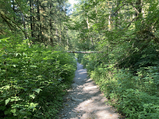
I visited both Bridal Veil Falls (7 km or 4.4 miles total; car-falls-car) and Lake Serene (15 km or 9.4 miles total; car-lake-car), not on the same day, but a few weeks apart. For the first 2 km (1.25 miles) or so, the trail for both is the same (and quite flat and uninteresting). I did both trails on Friday afternoons, and still, the parking lot (Northwest Forest Pass required) was almost full; however, I got a spot for my car (weekend parking will be very difficult). While doing the initial stretch of the trail, I was wondering if the trail was going to get any better. But, at 2 km (1.25 miles) from the trailhead comes a bifurcation in the trail (sign board - note that actual distances are almost double) - one trail goes to Lake Serene, which is 3.25 miles or 5.5 km from this point, and the other goes to Bridal Veil Falls, which is 1 mile or 1.5 km from here. This is where the trails to the falls and to the lake suddenly become steep, beautiful, and interesting.
Bridal Veil Falls Trail:
The falls trail is quite rocky and a little difficult. Do wear good hike shoes and be careful in this stretch, especially when with children. Nonetheless, I saw quite a few families with small kids and dogs here. On my way up, everybody coming down appeared to be very happy, and they all cheered me up! :) They all said the falls was near and that I wouldn’t be disappointed. And then came the falls, and I, honestly, wasn’t disappointed at all. What I saw was a spectacular falls, which was totally worth the effort. You are so close to the falls here (as opposed to, say, at Wallace Falls), and of course, you can touch the waters. It was a very refreshing sight and place, and up there, it was a little cooler as well. Now, I would say that this trail is difficult and a little steep; however, the short distance makes it manageable and not so painful. I would recommend not combining this trail with the lake trail on the same day; do them on separate days, otherwise, you are looking at an 18-km (or 11.25 miles total) hard hike that might eventually become unmanageable.
Lake Serene Trail:
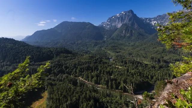
This trail is difficult, never-ending, time-consuming, and painful; however, the spectacular lake at the top will refresh you and make your hike totally worth it. It’s a straight-up hike, which will cause you 3-4 times the pain and sweat as the falls trail will. The trail gets quite narrow at several places and is very rocky. Do wear good hike shoes here and carry enough water and food - it’s more like a day-trip. I kept a slow pace and took quite a few breaks on the way, and it took me 3 hours to reach the lake, where I spent around 45 minutes before getting on my way back. Getting back from the lake to the trailhead took me 2 hours and 15 minutes (total hike - 6 hours); so, do plan accordingly. Lake Serene is serene indeed. Nestled high up in the mountains, this seemingly-shallow lake has a slight eerie feel to it and looks great to go swimming in. :) I wasn’t prepared for a swim, but I saw a few people swim in there; the water wasn’t that cold. You may check out the viewpoint a little higher up as well. The lake has crystal-clear waters and offers a very relaxing experience to everyone. I did see some snow in the mountains; however, the recent heat wave in WA had taken away almost all of the snow around the lake. I can imagine how beautiful this setting will be when there’s snow everywhere around the lake. Nonetheless, the lake, by itself, is very beautiful and a must-see. I would recommend doing this hike when the temperature is around 17-18 C (64-66 F). Apparently, I didn’t see many kids on the trail. And, it’s needless for me to mention that my knees were totally beat after this hike! ;)
The falls and the lake are a great spot and so close to the Greater Seattle Area. For the boring initial stretch, however, I am going to deduct a ⭐️; and just for what you get at the end, I would very much recommend both the trails. Lastly, a photo doesn’t do justice to the falls or to the lake; being physically present there offers quite a different...
Read more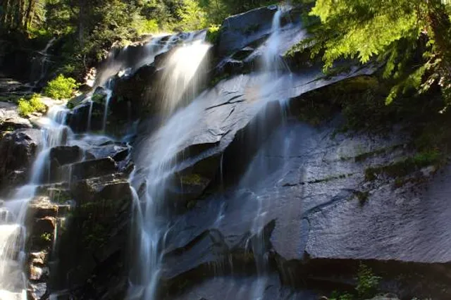


![[Mountain Collection] The Ultimate Hiking Guide Around Seattle (Part 4)](https://img2.boatcdn.com/media/t6rQNlSFR3u1nNdbMxJPfw)