HTML SitemapExplore
logo
Find Things to DoFind The Best Restaurants

Laurel Snow State Natural Area — Attraction in Tennessee

Name
Laurel Snow State Natural Area
Description
Laurel-Snow State Natural Area is a Tennessee Class II Natural-Scientific State Natural Area located in Rhea County, Tennessee, near Dayton, on Walden Ridge of the Cumberland Plateau. The 2,259-acre area is owned by the State of Tennessee and managed by the Tennessee Department of Environment and Conservation.
Nearby attractions
Pocket Wilderness
554 Pockett Wilderness Rd, Dayton, TN 37321
Laurel Snow State Natural Area Trailhead of the Cumberland Trail
1431 Back Valley Rd, Dayton, TN 37321
Nearby restaurants
Nearby hotels
Related posts
Keywords
Laurel Snow State Natural Area tourism.Laurel Snow State Natural Area hotels.Laurel Snow State Natural Area bed and breakfast. flights to Laurel Snow State Natural Area.Laurel Snow State Natural Area attractions.Laurel Snow State Natural Area restaurants.Laurel Snow State Natural Area travel.Laurel Snow State Natural Area travel guide.Laurel Snow State Natural Area travel blog.Laurel Snow State Natural Area pictures.Laurel Snow State Natural Area photos.Laurel Snow State Natural Area travel tips.Laurel Snow State Natural Area maps.Laurel Snow State Natural Area things to do.
Laurel Snow State Natural Area things to do, attractions, restaurants, events info and trip planning
Laurel Snow State Natural Area
United StatesTennesseeLaurel Snow State Natural Area

Basic Info

Laurel Snow State Natural Area

1098 Pockett Wilderness Rd #100, Dayton, TN 37321
4.8(317)
Open 24 hours
Save
spot

Ratings & Description

Info

Laurel-Snow State Natural Area is a Tennessee Class II Natural-Scientific State Natural Area located in Rhea County, Tennessee, near Dayton, on Walden Ridge of the Cumberland Plateau. The 2,259-acre area is owned by the State of Tennessee and managed by the Tennessee Department of Environment and Conservation.

Outdoor
Adventure
Cultural
Scenic
Off the beaten path
Family friendly
Pet friendly
attractions: Pocket Wilderness, Laurel Snow State Natural Area Trailhead of the Cumberland Trail, restaurants:
logoLearn more insights from Wanderboat AI.
Phone
(432) 566-2229
Website
tn.gov

Plan your stay

hotel
Pet-friendly Hotels in Tennessee
Find a cozy hotel nearby and make it a full experience.
hotel
Affordable Hotels in Tennessee
Find a cozy hotel nearby and make it a full experience.
hotel
The Coolest Hotels You Haven't Heard Of (Yet)
Find a cozy hotel nearby and make it a full experience.
hotel
Trending Stays Worth the Hype in Tennessee
Find a cozy hotel nearby and make it a full experience.

Reviews

Nearby attractions of Laurel Snow State Natural Area

Pocket Wilderness

Laurel Snow State Natural Area Trailhead of the Cumberland Trail

Pocket Wilderness

Pocket Wilderness

4.7

(34)

Open 24 hours
Click for details
Laurel Snow State Natural Area Trailhead of the Cumberland Trail

Laurel Snow State Natural Area Trailhead of the Cumberland Trail

5.0

(4)

Open 24 hours
Click for details

Things to do nearby

Merry & Bright 5K
Merry & Bright 5K
Thu, Dec 18 • 5:30 PM
Main Street, Pikeville, TN 37367
View details
Get the Appoverlay
Get the AppOne tap to find yournext favorite spots!
Wanderboat LogoWanderboat

Your everyday Al companion for getaway ideas

CompanyAbout Us
InformationAI Trip PlannerSitemap
SocialXInstagramTiktokLinkedin
LegalTerms of ServicePrivacy Policy

Get the app

© 2025 Wanderboat. All rights reserved.
logo

Reviews of Laurel Snow State Natural Area

4.8
(317)
avatar
5.0
3y

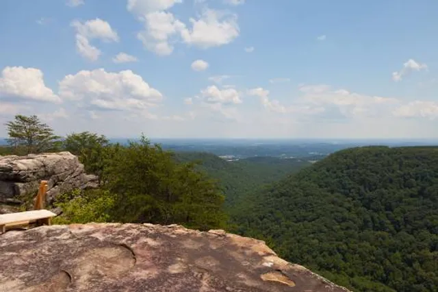
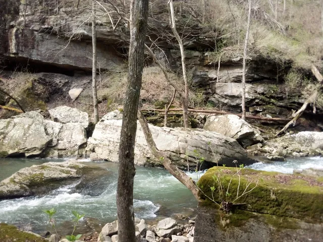
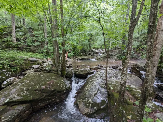
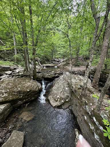
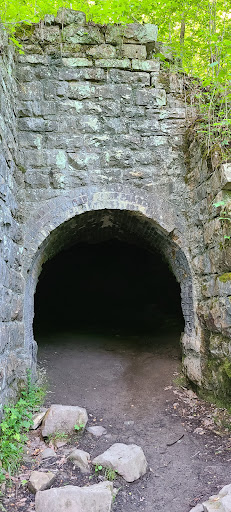
This is one of the most beautiful and interesting state natural areas I’ve seen. The area was a coal and iron mine in the late 1800s and early 1900s, and many of the mines are still intact, others have reclaimed by nature. The Richland mine, which is the most commonly photographed and easiest to find is right along the trail. It has an intriguing history, and I recommend researching it before you go, or after, to learn the history of the area. The Nelson mine is nearby, but is not in public land, and it’s completely flooded, and the surrounding area is somewhat unsafe, so it’s better to stick to the eastern side of Richland creek. There is also the new prospect mine, with very little information regarding it’s purpose and history, it might just remain somewhat of a mystery. Another interesting mine is the Dixon slope mine, which is somewhat harder to find. It’s main entrance has collapsed and been reclaimed by nature, but the ventilation shaft is probably still intact, although it is hard to find. I searched all around the rock face near the original Dixon slope mine entrance, and was unable to find the ventilation shaft. The Richland mine is right beside the trail, and is always flooded at least partially, however during droughts or just a normal dry season, you can go deeper in then you usually can, and see the interior of the mine past where the water level usually is. Like I said earlier I highly recommend doing some research on the history, as it’s way more then I could ever fit in a review. In addition to the man made underground features, there are also some naturally occurring caves in the area. I found one under a giant rock by the creek. You have to crawl to get inside, and it’s a pretty strenuous journey, and I never found the end, so I may have been near the end, or it may have gone further back. I didn’t go too far back, but it is deep enough to be worth exploring. We hiked to the area near laurel falls, which also contains a super small cave near lower laurel falls, just past the large bridge, the third one on that trail. The trail itself is beautiful, with Richland creek right beside you for the first part of the hike. We went when it was pretty icy, so do be cautious of slick surfaces. There is lots of backpacking at this park, and we passed a lot of people coming back from multi day trips further inside the park. There is rumored to be a cougar that once inhabited the park, and this might be true. I looked for his cave along the rock face but didn’t find it. I plan to return, and when I do I’ll update this review and say whether or not I found the cave and the ventilation shaft for the Dixon slope mine. We saw a coyote climbing up a rock face, which was one of the coolest things I’ve seen. The coke ovens are located near the parking lot, though they are often times covered In kudzu. Depending on the season and how the waters are, there are some good swimming spots along the trail. Do be aware that sometimes though the water can have a very strong current. As a history and spelunking nerd I absolutely love this place, because of the mines and caves, but anyone will enjoy this place if your looking to get out into nature. I could go on and in all day, but I think I’ll wrap up this review now, but I will give an update in a few weeks once I go back and search for the other one and the cougar cave. Definitely a five star. If you need directions to the mines, I will do my best to explain how to find them. To find the original entrance to the Dixon slope mine, look for the first bridge you come across. It’s right by the trailhead, and it’s pretty hard to miss. There is a large stone wall, it’s hard to tell what it was, but it’s big, so you’ll probably see it. Go towards it, and there is a small side trail. Get on that trail, and you’ll find after about two hundred feet, there is some old ruins near the trail, that’s the Dixon slope mine, the original entrance. Unfortunately I’ve hit the limit of how long a review can be, so if you want to learn more read other reviews or do some...

   Read more
avatar
5.0
7y

Ever feel like your being watched?! Beautiful place. A lot of history. I would recommend reading some history on the place before visiting. The only downfall is the amount of copperhead snakes. Plus cougars. We had an incident we walked up on a cave. We took a picture of inside the cave, upon further investigation we noticed we caught him in the picture. We had no clue we were standing in the mouth of a cougars home!! His cave is above the mine. There is a trail you can take to the top of the mine which is actually the ventilation shaft on the main trail... back up the trail (towards the trailhead) There is a trail to the actual mine that collapsed that sits above and to the right of the vent shaft.. You can follow the rock wall to the end and there is a trail that goes all the way up to the rock face. There is the cougars cave. There are scratches on trees, and you can see where he lays. A few years back the old man who locks up said there was a mother and her 2 cubs. Nobody ever belived him. Its true. We were stalked the entire way back to...

   Read more
avatar
2.0
4y

This pocket park is so much more then just a park. It's also a walk thru history. Just below the parking area is a row of coke ovens. The main path mostly follows the river. The first short bridge has some workings under it most likely a dam. If you follow that stream, it's not a easy walk following it up. But when you get to the top you'll find a fairly large cave that the stream is flowing out of. Back on the main trail a short ways is what was a coal mine. Up above the arched door is a very large stone arch That was the coal mine, all collapsed now. The arched door on the trail is a fair sized room. At the back of the room a tunnel leads off to the left. The back of the room into that tunnel is flooded. It is a great little room to cool of in. As you head up the trail you will see random bits of history both in the river and on land. You will see a Black pipe on the trail. That was the water supply for Dayton. To be...

   Read more
Page 1 of 7
Previous
Next

Posts

Helen BlairHelen Blair
While this was a beautiful area to visit, it is very easy to get lost even if you stay on the trail. The signage is lacking, and the trails can lead to dead ends. Went in at 4:30 for a supposed 2.5 mile hike in and back out. Wandered around lost for some time, and never left the trail. Made it out at 8 pm, and the gate was locked. Had to call the sheriffs department to open the gate. It would be helpful if there were more signs, including one pointing towards the exit back to the parking lot. Go early so you have plenty of time to find your way back out. I am relatively fit and was able to climb over the boulders near the falls. A less fit person may struggle with some points on the trails. Also beware of the road in as it is “Unimproved.” Seems like they need to upgrade the road in, and add signage. Easy fixes to make this a more enjoyable area to visit.
Charles PickrellCharles Pickrell
This was my first visit to Laurel Snow State Natural Area, but, will not be my last. The trail toward the falls is well maintained. Some of it is flat and gravelly. Other parts are uphill and have a lot of rocky paths . A good walking stick and supportive shoes are suggested. As you walk the trails the sound of flowing water wash away any cares you may have brought with you when you arrived. The trail to Laurel Falls is about 4 miles so allow sufficient time to get the full benefit of your visit. One word of caution, however. The approach road to the parking lot from the main road is gravel and has lots of potholes. So, be careful and drive slowly as you are arriving. But don't let this discourage you from visiting. I promise, you will not regret it
Andrew DavidAndrew David
Fantastic FREE nature area! This hidden gem near Dayton TN is one of the most beautiful places in the state. There is a gorgeous river flowing through the park that parallels the majority of the trail. There are several good swimming areas along the river with small falls and stunning rock features along the way. There are 3 designated camp sites available for reservation on the state park website. Overnight parking at this location is permitted, although the entrance gate will close nightly around 8 p.m. The only negative remark I can give to this park is how horribly rutted and pot-hole littered road to the park. However, the road is easily traversable with any road worthy vehicle. Just take it slow.
See more posts
See more posts
hotel
Find your stay

Pet-friendly Hotels in Tennessee

Find a cozy hotel nearby and make it a full experience.

While this was a beautiful area to visit, it is very easy to get lost even if you stay on the trail. The signage is lacking, and the trails can lead to dead ends. Went in at 4:30 for a supposed 2.5 mile hike in and back out. Wandered around lost for some time, and never left the trail. Made it out at 8 pm, and the gate was locked. Had to call the sheriffs department to open the gate. It would be helpful if there were more signs, including one pointing towards the exit back to the parking lot. Go early so you have plenty of time to find your way back out. I am relatively fit and was able to climb over the boulders near the falls. A less fit person may struggle with some points on the trails. Also beware of the road in as it is “Unimproved.” Seems like they need to upgrade the road in, and add signage. Easy fixes to make this a more enjoyable area to visit.
Helen Blair

Helen Blair

hotel
Find your stay

Affordable Hotels in Tennessee

Find a cozy hotel nearby and make it a full experience.

Get the Appoverlay
Get the AppOne tap to find yournext favorite spots!
This was my first visit to Laurel Snow State Natural Area, but, will not be my last. The trail toward the falls is well maintained. Some of it is flat and gravelly. Other parts are uphill and have a lot of rocky paths . A good walking stick and supportive shoes are suggested. As you walk the trails the sound of flowing water wash away any cares you may have brought with you when you arrived. The trail to Laurel Falls is about 4 miles so allow sufficient time to get the full benefit of your visit. One word of caution, however. The approach road to the parking lot from the main road is gravel and has lots of potholes. So, be careful and drive slowly as you are arriving. But don't let this discourage you from visiting. I promise, you will not regret it
Charles Pickrell

Charles Pickrell

hotel
Find your stay

The Coolest Hotels You Haven't Heard Of (Yet)

Find a cozy hotel nearby and make it a full experience.

hotel
Find your stay

Trending Stays Worth the Hype in Tennessee

Find a cozy hotel nearby and make it a full experience.

Fantastic FREE nature area! This hidden gem near Dayton TN is one of the most beautiful places in the state. There is a gorgeous river flowing through the park that parallels the majority of the trail. There are several good swimming areas along the river with small falls and stunning rock features along the way. There are 3 designated camp sites available for reservation on the state park website. Overnight parking at this location is permitted, although the entrance gate will close nightly around 8 p.m. The only negative remark I can give to this park is how horribly rutted and pot-hole littered road to the park. However, the road is easily traversable with any road worthy vehicle. Just take it slow.
Andrew David

Andrew David

See more posts
See more posts