Tuxedo-Mount Ivy Trailhead (T-MI) things to do, attractions, restaurants, events info and trip planning

Basic Info
Tuxedo-Mount Ivy Trailhead (T-MI)
Ramapo, NY 10970
4.4(9)
Open until 12:00 AM
Save
spot
spot
Ratings & Description
Info
Outdoor
Adventure
Scenic
Pet friendly
Family friendly
Off the beaten path
attractions: Sri Ranganatha Temple, restaurants: , local businesses: Sri Ranganatha Temple, BIAGO, Camp Ramaquois
Website
parks.ny.gov
Open hoursSee all hours
WedOpen 24 hoursOpen
Plan your stay

Pet-friendly Hotels in Town of Ramapo
Find a cozy hotel nearby and make it a full experience.

Affordable Hotels in Town of Ramapo
Find a cozy hotel nearby and make it a full experience.

The Coolest Hotels You Haven't Heard Of (Yet)
Find a cozy hotel nearby and make it a full experience.

Trending Stays Worth the Hype in Town of Ramapo
Find a cozy hotel nearby and make it a full experience.
Reviews
Live events

Dopamine Land: A Multisensory Experience
Wed, Jan 28 • 2:00 PM
One Garden State Plaza Pkwy, Paramus, 07652
View details

Sleepy Hollow Murder Mystery: Solve the case!
Thu, Jan 1 • 12:00 AM
121 N Broadway, Tarrytown, 10591
View details

Parking Lehigh Mountain Hawks at Army Black Knights Mens Basketball
Wed, Jan 28 • 8:30 AM
Christl Arena, 700 Mills Road, West Point, NY 10996, US, United States
View details
Nearby attractions of Tuxedo-Mount Ivy Trailhead (T-MI)
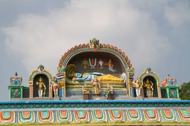
Sri Ranganatha Temple

Sri Ranganatha Temple
4.9
(645)
Closed
Click for details
Nearby local services of Tuxedo-Mount Ivy Trailhead (T-MI)
Sri Ranganatha Temple
BIAGO
Camp Ramaquois
Sri Ranganatha Temple
4.9
(556)
Click for details

BIAGO
5.0
(28)
Click for details

Camp Ramaquois
4.9
(119)
Click for details