During the mid-Eocene, it is believed that the drainage basin of the Amazon was split along the middle of the continent by the Purus Arch. Water on the eastern side flowed toward the Atlantic, while to the west water flowed toward the Pacific across the Amazonas Basin. As the Andes Mountains rose, however, a large basin was created that enclosed a lake; now known as the Solimões Basin. Within the last 5–10 million years, this accumulating water broke through the Purus Arch, joining the easterly flow toward the Atlantic.14 There is evidence that there have been significant changes in the Amazon rainforest vegetation over the last 21,000 years through the last glacial maximum (LGM) and subsequent deglaciation. Analyses of sediment deposits from Amazon basin paleolakes and the Amazon Fan indicate that rainfall in the basin during the LGM was lower than for the present, and this was almost certainly associated with reduced moist tropical vegetation cover in the basin.16] There is a debate, however, over how extensive this reduction was. Some scientists argue that the rainforest was reduced to small, isolated refugia separated by open forest and grassland;[17] other scientists argue that the rainforest remained largely intact but extended less far to the north, south, and east than is seen today.[18] This debate has proved difficult to resolve because the practical limitations of working in the rainforest mean that data sampling is biased away from the center of the Amazon basin, and both explanations are reasonably well supported by the available data.
Sahara Desert dust windblown to the Amazon
More than 56% of the dust fertilizing the Amazon rainforest comes from the Bodélé depression in Northern Chad in the Sahara desert. The dust contains phosphorus, important for plant growth. The yearly Sahara dust replaces the equivalent amount of phosphorus washed away yearly in Amazon soil from rains and floods.[19] NASA's CALIPSO satellite has measured the amount of dust transported by wind from the Sahara to the Amazon: an average of 182 million tons of dust are windblown out of the Sahara each year, at 15 degrees west longitude, across 2,600 km (1,600 mi) over the Atlantic Ocean (some dust falls into the Atlantic), then at 35 degrees West longitude at the eastern coast of South America, 27.7 million tons (15%) of dust fall over the Amazon basin (22 million tons of it consisting of phosphorus), 132 million tons of dust remain in the air, 43 million tons of dust are windblown and falls on the Caribbean Sea, past 75 degrees west longitude.[20] CALIPSO uses a laser range finder to scan the Earth's atmosphere for the vertical distribution of dust and other aerosols. CALIPSO regularly tracks the Sahara-Amazon dust plume. CALIPSO has measured variations in the dust amounts transported – an 86 percent drop between the highest amount of dust transported in 2007 and the lowest in 2011. A possibility causing the variation is the Sahel, a strip of semi-arid land on the southern border of the Sahara. When rain amounts in the Sahel are higher, the volume of dust is lower. The higher rainfall could make more vegetation grow in the Sahel, leaving less sand exposed to winds to blow away.[21] Amazon phosphorus also comes as smoke due to biomass burning...
Read moreInside the Amazon 
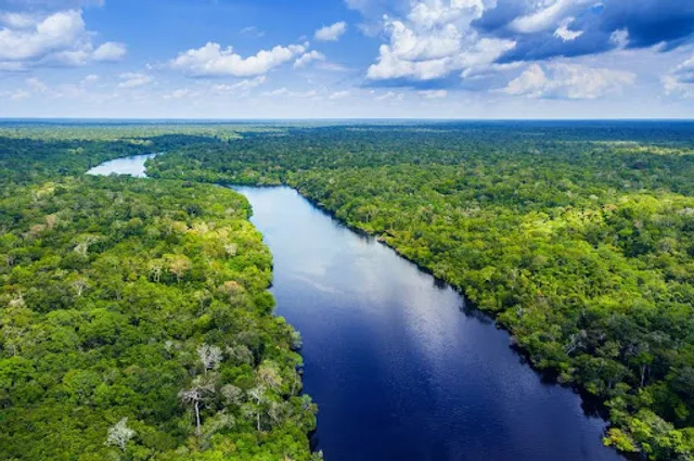
Spanning 6.7 million km2 (twice the size of India) the Amazon Biome is virtually unrivalled in scale, complexity and opportunity, and truly is a region distinguished by superlatives. Not only does the Amazon encompass the single largest remaining tropical rainforest in the world, it also houses at least 10% of the world’s known biodiversity, including endemic and endangered flora and fauna, and its river accounts for 15-16% of the world’s total river discharge into the oceans. The Amazon River flows for more than 6,600 km, and with its hundreds of tributaries and streams contains the largest number of freshwater fish species in the world.
Natural and cultural diversity
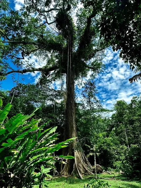
Equally impressive are the unfathomable numbers of mammals, birds, amphibians, and reptiles4 found across the biome. The Amazon is home to more than 30 million people living across a vast region subdivided into nine different national political systems.
According to the Coordinator of Indigenous Organizations of the Amazon Basin (COICA), about 9% (2.7 million) of the Amazon’s population is still made up of indigenous people – 350 different ethnic groups, more than 60 of which still remain largely isolated. And yet, for all of its magnitude and apparent remoteness, the Amazon Biome is surprisingly fragile and close to each one of us.
Jeopardizing a pillar of life on Earth
During the last half century, the seemingly endless Amazon has lost at least 17% of its forest cover, its connectivity has been increasingly disrupted, and numerous endemic species have been subjected to waves of resource exploitation. The economic transformation of the Amazon based on the conversion and degradation of its natural habitat is gaining momentum. Yet, as those forces grow in strength, we are also finding that the Amazon plays a critical role in maintaining climate function regionally and globally, a contribution which everyone–rich or poor–depends on.
The Amazon’s canopy cover helps regulate temperature and humidity, and is intricately linked to regional climate patterns through hydrological cycles that depend on the forests. Given the enormous amount of carbon stored in the forests of the Amazon, there is tremendous potential to alter global climate if not properly stewarded. The Amazon contains 90-140 billion metric tons of carbon, the release of even a portion of which would accelerate global warming significantly. Currently, land conversion and deforestation in the Amazon release up to 0.5 billion metric tons of carbon per year, not including emissions from forest fires, thus rendering the Amazon an important factor in regulating global climate (Nepstad et al 2008). Quick facts
The Amazon biome is 2 times the size of India The Amazon river is over 6600 km long It harbors 10% of the world´s known species It is home to 350 ethnic groups 17% of the forest cover has been lost in the...
Read moreThe Amazon basin is the largest tropical rainforest in the world, covering a size approximately equal to the lower 48 United States. 6-8 million square kilometers of forest house approximately 10% of the world’s biodiversity and 15% of its freshwater. These “lungs of the world” provide ecological services for the planet, but also a source of livelihood for hundred of indigenous groups and forest dependent peoples. Brazil is home to approximately 65% of the Amazon basin (see side graphic).
The forests of the Amazon basin have been used for food and resources for thousands of years by native peoples; products such as rubber, palm fruits, and Brazil nuts, as well as countless medicines have been derived from the forest. In the last centuries, rubber harvest and timber extraction of valuable woods such as mahogany and Spanish cedar penetrated remote areas of the Amazon forest, often via waterways such as the Amazon and Xingu. Beginning in the 1907’s and 80’s, deforestation exploded as highways such as the Trans-Amazonas in Para and the soy highway (BR-163) in Mato Grosso opened up new land to permanent settlement. Since 1970 an estimated 700,000 square kilometers, or 20% of Brazil’s Amazon forest has been cleared. Deforestation levels reached 20,000 square kilometers per year for much of 1980-2005, an area almost the size of Belgium. Cattle ranching and soy plantations are the dominant drivers of deforestation in the Amazon, much of it concentrated in massive landholdings of thousands of acres. Expansion of the road network through the Amazon basin, especially in the southwest Brazil – Peru – Bolivia region continue to threaten Amazon forests. New threats emerge from palm oil plantations, mining, and hydropower development. Moreover, scientists estimate that a similar extent of forest is threatened by degradation from climate change, drought, and unsustainable selective logging practices.
Despite the numerous deforestation threats facing the forest, deforestation in the Amazon basin has declined since 2005, and the region as a whole still boasts some of the most intact and healthy tropical forests in the world. Brazil has been commended for great advances in environmental policy, forest monitoring, and protected area management. Conservationists seek to continue these advances with REDD+ and other environmental incentive programs, deforestation free supply chains of major commodities, and land tenure reform. At the same time, indigenous reserves, forest restoration, timber legality and forest certification, and marketing of non-timber forest products remain important conservation tools. Explore these pages to learn more about the Amazon basin forests: ecology and habitat types, forest management, land use, governance, and...
Read more