HTML SitemapExplore
logo
Find Things to DoFind The Best Restaurants

Mount Teide — Attraction in La Orotava

Name
Mount Teide
Description
Teide, or Mount Teide, is a volcano on Tenerife in the Canary Islands, Spain. Its summit is the highest point in Spain and the highest point above sea level in the islands of the Atlantic.
Nearby attractions
Mount Teide
38300, Santa Cruz de Tenerife, Spain
Mirador del Teide
Unnamed Road, 38300, 38300, Santa Cruz de Tenerife, Spain
Nearby restaurants
Related posts
Keywords
Mount Teide tourism.Mount Teide hotels.Mount Teide bed and breakfast. flights to Mount Teide.Mount Teide attractions.Mount Teide restaurants.Mount Teide travel.Mount Teide travel guide.Mount Teide travel blog.Mount Teide pictures.Mount Teide photos.Mount Teide travel tips.Mount Teide maps.Mount Teide things to do.
Mount Teide things to do, attractions, restaurants, events info and trip planning
Mount Teide
SpainCanary IslandsLa OrotavaMount Teide

Basic Info

Mount Teide

38300, Santa Cruz de Tenerife, Spain
4.8(4K)
Open 24 hours
Save
spot

Ratings & Description

Info

Teide, or Mount Teide, is a volcano on Tenerife in the Canary Islands, Spain. Its summit is the highest point in Spain and the highest point above sea level in the islands of the Atlantic.

Outdoor
Adventure
Family friendly
attractions: Mount Teide, Mirador del Teide, restaurants:
logoLearn more insights from Wanderboat AI.

Plan your stay

hotel
Pet-friendly Hotels in La Orotava
Find a cozy hotel nearby and make it a full experience.
hotel
Affordable Hotels in La Orotava
Find a cozy hotel nearby and make it a full experience.
hotel
The Coolest Hotels You Haven't Heard Of (Yet)
Find a cozy hotel nearby and make it a full experience.
hotel
Trending Stays Worth the Hype in La Orotava
Find a cozy hotel nearby and make it a full experience.

Reviews

Nearby attractions of Mount Teide

Mount Teide

Mirador del Teide

Mount Teide

Mount Teide

4.8

(632)

Open 24 hours
Click for details
Mirador del Teide

Mirador del Teide

4.8

(727)

Open 24 hours
Click for details

Things to do nearby

The edible forest and vanilla cultivation
Thu, Dec 4 • 11:30 AM
38470, Los Silos, Canarias, Spain
View details
Enjoy snorkeling surrounded by different fishes
Fri, Dec 5 • 1:00 PM
38002, Alcalá, Canarias, Spain
View details
Sunset and stargazing walk near Teide
Fri, Dec 5 • 5:00 PM
Santa Cruz de Tenerife, Canarias, Spain
View details
Get the Appoverlay
Get the AppOne tap to find yournext favorite spots!
Wanderboat LogoWanderboat

Your everyday Al companion for getaway ideas

CompanyAbout Us
InformationAI Trip PlannerSitemap
SocialXInstagramTiktokLinkedin
LegalTerms of ServicePrivacy Policy

Get the app

© 2025 Wanderboat. All rights reserved.
logo

Reviews of Mount Teide

4.8
(3,987)
avatar
5.0
4y

How to visit.

🚠 Cable car: last cable car from the top goes at 5:20 pm. Normally cable car goes every 10 minutes. In most cases, you don't need to purchase tickets in advance, but to be on the safe side you can buy tickets before you go. Prices are 37 up-down or 21 for one direction.

🚏Parking: it’s free, maybe be crowded, but anyway you can park, the question is the distance from the cable car station. The best option is to drive to the station trying to find a slot.

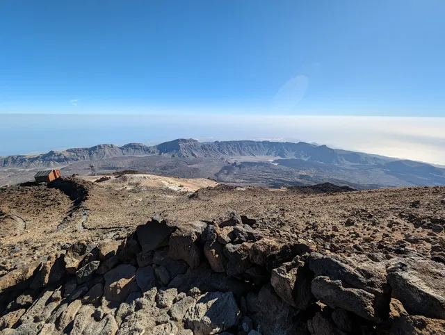
📍Distance and travel time. Check on google and multiply by 2 as it’s a mountain road + you will make several stops to take photos. No gas stations are on the top(1000m above the sea level) but you have almost zero risk as you can drive down on neutral without pressing the gas pedal. Anyway better to have fuel to feel confident.

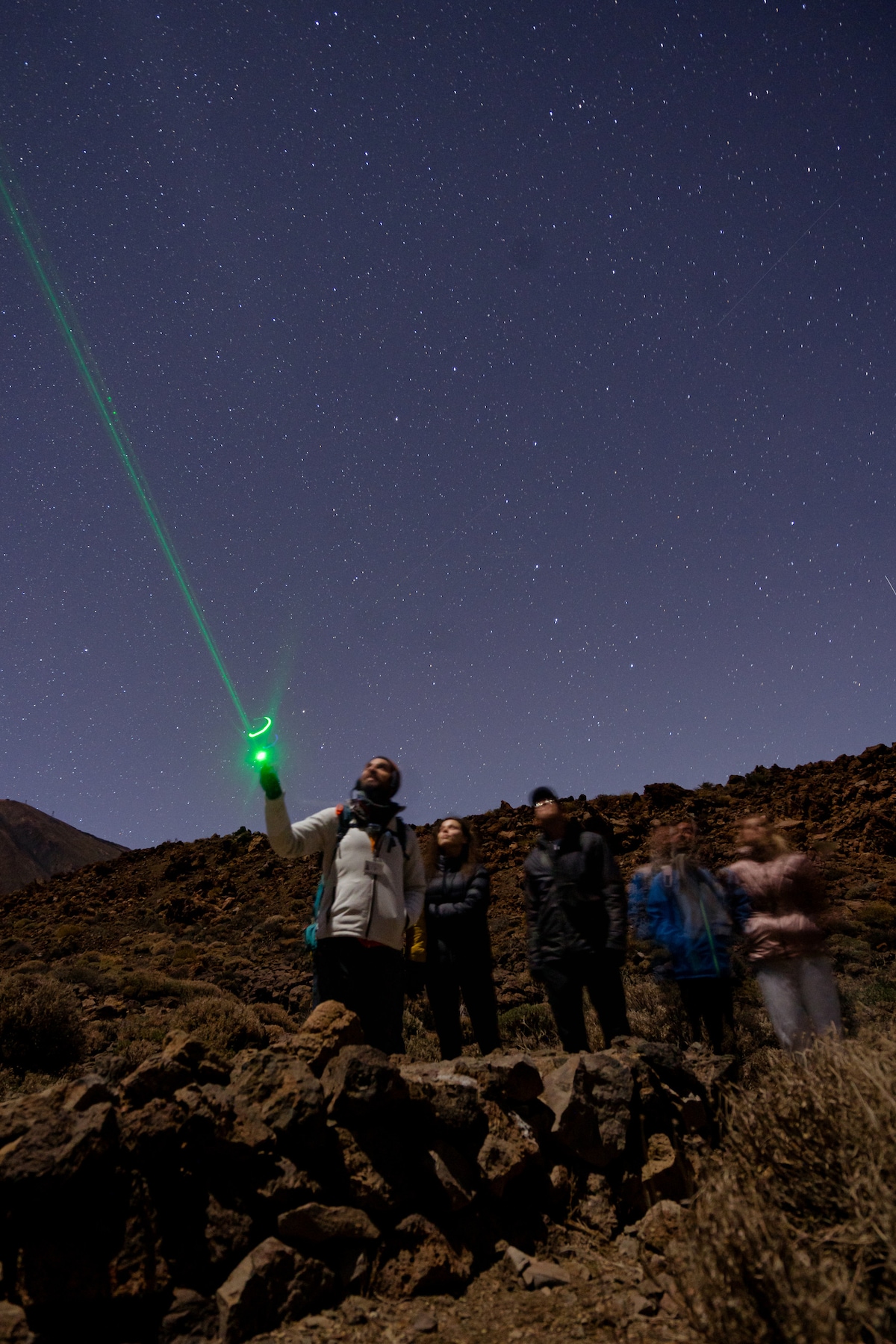
☀️Sun and weather. It’s very very sunny near the cable car station, on the top station and even on the way to Tiede. Sun protection cream and sunglasses are recommended. The way from 1000m to 2000m way be foggy 🌫 , rainy🌧. It’s difficult to drive back from the mountains in the fog😶‍🌫️ after the sunset, but it’s possible. It’s tricky expensive to drive using GPS🧭 and see only a few meters ahead. GPS is a must-have thing. Not because of the route complexity but because of the drive in dark fog. Better to see them turn on the map in case if you observe only a few meters in the windshield.

🚘Car: better to take a small car as it is easier to drive serpentines. You don’t need much power to climb roads in Tenerife. So don’t need to take a sedan or SUV. 🚌Bus: it’s an option but less interesting as you can’t stop everywhere you want. Moreover car rental is cheaper for 2 or more people. Information that it’s difficult to park a car - just a fake to sell you bus tickets.

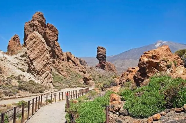
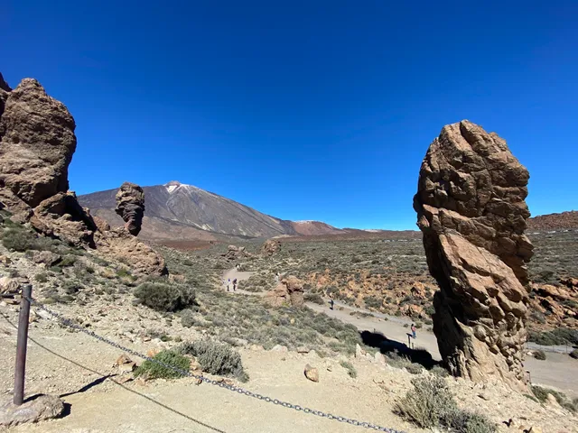
🛂Pass to the top: after a cable car, you have 170m to the top. It’s a trial with a special pass which you need to order in advance. Most like you didn’t order it and thinking is it possible to show them pass for the next month instead of pass for today. It works. They just ask you to show your pass number and ID/passport. So it is worse to try and in most cases, it works. You need 40 min to the top + 30 minutes down to the cable car

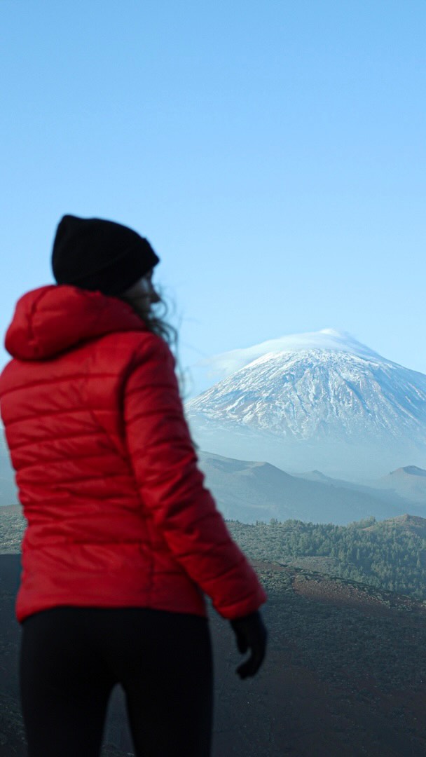
👕🥾Cloth, shoes and other equipment: you need a backpack 🎒 to put warm clothes which you will put on on the top cable car station. Approximately it’s-20 degrees vs seashore. Shoes: better to have sports shoes comfortable to walk on steps. Walking sticks can be helpful but not mandatory.

🥪🍌💧Food and water. Take everything with you. You will find only vending machines with a few small and expensive products. Restrooms as available on top and down stations.

📶Cellular and WiFi. There is no mobile connection on some parts of the road to Teide. Better to use build the route in the maps app at the start, most navigation software like Apple or Google Maps doesn’t require a constant connection. Download the offline maps like organic maps (former mapsme) to have a map in any situation. In addition, offline maps have trails routes. Near Tiede, you will have a cellular connection (including the internet). Also, free WiFi is available near the down station of the cable car, but it may be difficult to connect to the access point. Power-bank can be helpful if want to photo, videos and walk trails.

🦺Guides: you don’t need such services as going up by cable car doesn’t require any specific knowledge.

🧗🏼‍♀️Go up without cable car: yes, it’s possible. You need to take into consideration the cable car schedule to ride back. The trail can take 4-6hours depending on your speed. So you should start no later than 11:30 am, so that start from the seaside is about 09:30 am. You will need to buy a back ticket for the cable car which is costs 21. You don’t need professional equipment for the trail but you should be...

   Read more
avatar
3.0
3y

Unfortunately we had a bad experience here. But hopefully we can save someone else. We tried to book with an operator and were told to hold off booking till they were open on the Monday. We did, and missed all the tickets available for a family of five to go up on the cable car. So we thought we'd try to make the climb and booked five places down the mountain. We assumed as you can walk down the mountain that the point would arrive back at the cable cars, nope, it's a 4km distance away. We got to the cable cars and had seen the mount blanc path at the bus stop earlier. (Just to mention here we caught the 9.35am, 1.5 hour long bumpy bus ride from Puerto de la cruz, all three kids had been complaining of feeling sick and my eldest got off the bus and began suffering with shaky legs). 11.45am We walked back to the path from the cable cars in high temperatures all with long tracksuit pants (unlucky for us it was a very hot day) we didn't know if a bus would head back to the path and we didn't see one in the half hour it took to walk this distance. 12.15pm We were already tired from the heat but started up the path. 2.5km up this path our ten year old had complained constantly, I don't blame him. We walked a little futher but had to stop as all the kids by now were starving we had a quick lunch stop. 1.20pm My wife and youngest son split from myself, daughter 11 and son 13 we carried on up as they headed back down. 2pm leaving the shackles behind we had made good progress, just not good enough, we had to be back at the lower cable car point by 4pm to catch the bus back, we had less than 2 hours including whatever queue may have been awaiting at the top for the ride down. Anyhow, we had reached the bottom of what I can only describe as mountain goat territory. I thought to myself skiberdy toilet, as we saw the signpost 4.7km to the upper cable car point. If I had to guess it looked like we had to walk up the Eiffel tower in zigzagged portions. My daughter must have jumped and screamed twenty times by the fourth zig, due to all the lizards and crickets zipping either side of the small path. My heart was beating out of my chest. I knew that was it, I stopped and called it, we had to go back down, it was the only sensible thing to do. We had a quick look at the nearby viewpoint 0.7 km away from this point took a few photos and headed back. 3.20pm my wife and youngest were still at the bottom just getting aboard a bus back to the cable car point, we all hugged each other in relief, (this detail may have been exaggerated for comedic effect, my wife never hugs me) my wife mentioned something about the film the impossible. Anyway we made it back for the 4pm bus back down to Puerto de la cruz the kids fell asleep. The parents felt sick on the drive back down. So you still want to go up... Ensure you book the cable car up, we had a bad experience make sure you don't, book early. If you are walking up, I don't recommend going up the mount blanc path for children under the age of 12/13. Carry plenty of water, we had about 3 litres. It wasn't enough. Make sure if you're walking up you get off at the stop prior to the cable cars as THERE IS NO PATH UP FROM THE LOWER CABLE CARS. The walk up the path from mount blanc stop is about 8km long up a 1200m ascent. It's going to take 4 to 5 hours to get up. The ascent gets harder after the first 3.3km it isn't a gradual change. Eye protection is also a good idea, the wind can pick up the dust on the ground. Please have a good time there I hope this info helps someone else. We would also like to thank the ticket office for refunding our tickets for the descent that we failed to make. This allows me to give the three stars. It's an experience I'm sure that our children will never be able...

   Read more
avatar
4.0
35w

I read many bad reviews here and I cannot comment on the cable car situation as we went up and down by foot. Yes, you need a permit for the peak and yes if on that day the trail is closed for ice/snow/whatever, you are screwed. This permit you need to get at least 3 month in advance for a specific day and hour! You also need a permit for the Montana Blanca - La Rambleta part and we were checked 3(!) times on this section. Some park employees were friendly, others less so, but noone really bothered us. This permit to La Rambletta is weird, it is valid for 6 hours, while getting only up can be anything from 4 to 6 hours in itself unless you rush up, so technically it is not possible to go up/down during the validity of the permit. And you cannot get a second permit for the same day. We arrived to the upper cable station an hour before our peak permit's valability, but were let in for the final part without having to wait. That was very nice from them! This made the descent much less stressful. Now about the mountain itself: it is a high mountain, so be prepared to changing conditions. Can be cold, can be sunny, can (and will be) windy, can be cloudy and rainy. Forecast suggested sun/cloud and around 0 degrees, but it was actually sunny and unless you were in a shade and wind for long it felt quite warm. Be prepared for the altitude, both if going up by the cable car or by foot. At 3500/3700 m you will probably feel the lack of oxigen pressure. Going slower might help. Even going slowly it is doable up-down with rests, eating, etc. in 10 hours. Be prepared with adequate clothing, footware. We saw many people with light equipment, and although this might work on a specific day, better not risk. The path technically is easy, the gradient is not that big (despite what the Volcano Teide site says), but you still need to walk 1400m up and down, so don't underestimate it. Views are nice especially from the top where you have almost 360 degree view, it is varied, though I'd not call so amazing as some other high peaks eg. in the Alps. Expect to see clouds towards north . :) 4 stars is because of that and the permit system... Also the cable car-Mirador El Fortalezza part is crowded. They want as much tourists as possible there who pay, but still limit the number of people to protect the area. Go figure... Go early (like before 9AM, even close to 8AM) before parking spots get full. At Montana Blanca there are only a few places, if you don't find a spot (we didn't at 8:30 AM), turn around and find another one (either the first, or at the cable car station). Don't go forward as they are further. Don't leave valuables in the car and nothing that could visually attract a thief. We had no issue, but there are signs about it, take it seriously. Actually all information is available online, but somewhat scattered around. To be clear: Teide peak permit can be obtained from reservasparquesnacionales site,

Select Público en general / General public .

If hiking up aim for the permits from 13:00 or 15:00. You should be able to get down in daylight (but still bring a headlight) also if you start your hike back from the cable care station at 16:00, assuming they let you go down.

Hiking permit from Montana Blanca can be obtained here (3 weeks before the start date) can be obtained from tenerifeon site for route PNT-07.

Read all the conditions on...

   Read more
Page 1 of 7
Previous
Next

Posts

Your browser does not support the video tag.
bucketlistersbucketlisters
Street surfing above the clouds!📍Mount Teide, Canary islands in Spain. 🎥: @jaaviaguilar #BucketListers #BucketList
Your browser does not support the video tag.
thegingerwanderlustthegingerwanderlust
Paradise on earth - The Canary Islands 🇮🇨😍 …. 📍 Sotavento, Fuerteventura 📍 Natural Pool, Fuerteventura 📍 @fincaelpatio Tenerife 📍 Corralejo dunes, Fuerteventura 📍 Pico Berigoyo, La Palma 📍 Mount Teide, Tenerife 📍 Punta de Hidalgo, Tenerife 📍 Los Tilos, La Palma 📍 Playa de Nogales, La Palma 📍 Porís de Candelaria, La Palma 📍 Cofete, Fuerteventura 📍 Garajonay National Park, La Gomera . . . . #paradiseonearth #travelreels #canaryislands #islascanarias #canariasviva #canariaslifestyle #latitudeoflife #latituddevida #fuerteventuraexperience #fuerteventuraisland #fuertevidorra #visitfuerteventura
Your browser does not support the video tag.
solowanderingsoulsolowanderingsoul
Here's your Easter vacation idea 👇👇 This village with a population of just 90 people is located in the office shore island of Spain, Tenerife. The village is called Masca. This is a perfect winter destination as it's warm throughout the year and you can enjoy its beautiful beaches, hike to an active volcano and also visit this place called as Machu Pichu of Spain. You can visit this in a day trip or a bus tour along with Teide Volcano and garachicho. And you will not regret it. Have you already planned your Easter vacation??? #machupicchu #masca #tenerife #travelgreen #greentravel
See more posts
See more posts
hotel
Find your stay

Pet-friendly Hotels in La Orotava

Find a cozy hotel nearby and make it a full experience.

Street surfing above the clouds!📍Mount Teide, Canary islands in Spain. 🎥: @jaaviaguilar #BucketListers #BucketList
bucketlisters

bucketlisters

hotel
Find your stay

Affordable Hotels in La Orotava

Find a cozy hotel nearby and make it a full experience.

Get the Appoverlay
Get the AppOne tap to find yournext favorite spots!
Paradise on earth - The Canary Islands 🇮🇨😍 …. 📍 Sotavento, Fuerteventura 📍 Natural Pool, Fuerteventura 📍 @fincaelpatio Tenerife 📍 Corralejo dunes, Fuerteventura 📍 Pico Berigoyo, La Palma 📍 Mount Teide, Tenerife 📍 Punta de Hidalgo, Tenerife 📍 Los Tilos, La Palma 📍 Playa de Nogales, La Palma 📍 Porís de Candelaria, La Palma 📍 Cofete, Fuerteventura 📍 Garajonay National Park, La Gomera . . . . #paradiseonearth #travelreels #canaryislands #islascanarias #canariasviva #canariaslifestyle #latitudeoflife #latituddevida #fuerteventuraexperience #fuerteventuraisland #fuertevidorra #visitfuerteventura
thegingerwanderlust

thegingerwanderlust

hotel
Find your stay

The Coolest Hotels You Haven't Heard Of (Yet)

Find a cozy hotel nearby and make it a full experience.

hotel
Find your stay

Trending Stays Worth the Hype in La Orotava

Find a cozy hotel nearby and make it a full experience.

Here's your Easter vacation idea 👇👇 This village with a population of just 90 people is located in the office shore island of Spain, Tenerife. The village is called Masca. This is a perfect winter destination as it's warm throughout the year and you can enjoy its beautiful beaches, hike to an active volcano and also visit this place called as Machu Pichu of Spain. You can visit this in a day trip or a bus tour along with Teide Volcano and garachicho. And you will not regret it. Have you already planned your Easter vacation??? #machupicchu #masca #tenerife #travelgreen #greentravel
solowanderingsoul

solowanderingsoul

See more posts
See more posts