Cactus to Clouds Trailhead
Cactus to Clouds Trailhead things to do, attractions, restaurants, events info and trip planning
Plan your stay
Posts
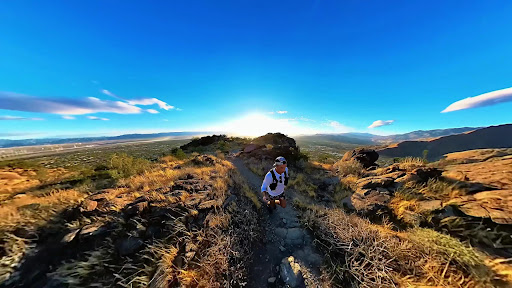
The absolute HARDEST day hike in the United States👇 Summiting Mt San Jacinto isn’t easy to begin with, but to make it even harder, we took an insane approach called Cactus to Clouds.🌵☁️ Starting on the desert floor in Palm Springs, we hiked all the way to the top of San Jacinto Peak, gaining over 11,000 ft of elevation in a single day. This has been one of the toughest challenges of my life. The treacherous climb, extreme temperatures, and challenging terrain will bring you to your breaking point. And from there, you have to make a decision… One that is as much mental as it is physical. Do you continue to push through the pain, or call it quits and give up on this dream? Well, as you can see I persevered. The moment I reached that peak I wanted to scream at the top of my lungs. I Fu***** did it!!!!! I made the climb that not many people are able to complete. But as joyous as this moment was, our day wasn’t over yet. We still had to hike 6 miles back down to the tram. The tram that most people take up the mountain and begin their trail from. Do you want to know the kicker? We were on a time crunch. The tram was closing soon and if we didn’t make it down in time, we would have to descend over 11,000 ft. That would have been an absolute killer on the knees and not to mention how many more hours it would have taken us. So after celebrating our summit, we packed up our things and rushed down with the little energy that we had left. Thankfully we made it. While enjoying the ride down, the whole day felt like a dream. Seeing the sheer depth of what we had just climbed, didn’t even seem real. 🏔️Would you attempt this hike? Let me know in comments! #visitcalifornia #socalhiker #sanjacinto #hikingbangers #travelcalifornia
bianca_velardibianca_velardi
46574
Feeling ON TOP OF THE WORLD after this hike! Cactus to Clouds is considered one of the hardest day hikes in the Continental US. We tracked it at 24 miles with 11,485 ft of elevation gain. I’ve never experienced pain like I did on this ascent, making it all that more fulfilling when we hit San Jacinto Peak! At 1:30 AM we hit the trail with our headlamps on. Starting basically at sea level, down with the cactuses, we were so excited to begin our day. This is a grueling hike so you need to start early. The first 5,000 ft of gain wasn’t so bad. And if you don’t know, this type of gain would normally be a tough hike in itself. But we still had to do that all over again and plus some. There were points where I just threw my things down and tried to take a nap. But I knew we didn’t have time to waste if we wanted to finish. So, we just kept climbing. The closer we got to the peak, the slower time moved. Our legs were burning, we were physically and mentally exhausted, and didn’t think we would make it. However, we trudged along knowing that we could not give up. The moment we reached the top and were above the clouds, I had such a feeling of accomplishment. All of the hard work paid off. But it wasn’t over yet. We still needed to hike back down. This is where the timing comes into play. Although you start the hike at the very bottom, you do not necessarily need to end it there. Instead, after reaching the peak, you hike back down part way to the tram which will then bring you back down to the bottom. The tram only runs until a certain time, so if you don’t make it there before closing, you will be stuck having to hike the rest of the way down. The reason for taking this is because the elevation loss is so great, it can be really hard on your knees. The total time it took us to finish was a full 16 hours. Do you think you would attempt this incredible hike? @getyourguide @getyourguidecommunity
bianca_velardibianca_velardi
31229
Hiked on 20 June 2022. Started walking at 3:15 AM and made it to the top 11 hours later. Was having a beer at the tram station 13 hours after starting. I wore Merrell MOABs and had no foot problems. Carried a 30lb pack with 2.5 liters of water that I refilled at the Lone Valley Ranger station. The first 4000’ or so is pretty straight up. It gets easier for about 2000’ more feet. But daggone from about 6300’ to 8400’ (tram valley) it is like climbing a ladder…if that ladder was made of loose shale and gravel. Seriously, you peel through altitude like a freakin marlin out in the deep blue on a thousand feet of 10lb test line. I was able to stay above the heat the entire way and once I got to 8400’ it was significantly easier. There is still a 10 mile round trip to the top and back to the tram. Can’t say the top is worth it because I have been in an airplane. It’s better if you just ride the tram up and drink a super expensive IPA and then ride the tram down. Same effect. 11/10 would recommend you take your ex on this hike. Edit: my first attempt ended in failure when my buddies legs quit at 5000’ feet and he got a free CHP helicopter ride to the bottom. The internet says it’s dangerous to do alone, but do you believe everything you read? I did it alone.
Jared GreenJared Green
280
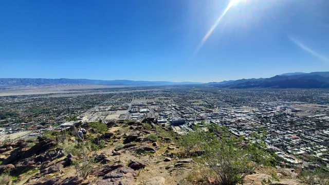
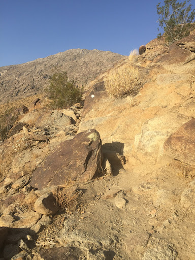
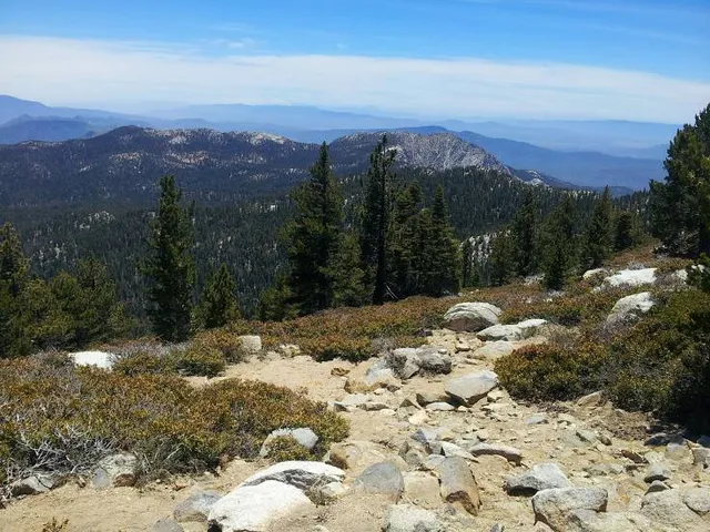
My hotel sat really close to the base of the hike near the museum. I was visiting Palm Springs with my mom and while I like to go on long walks every morning, she doesn't so I was by myself exploring the city on foot everyday. I had gone every direction from my hotel.....except up. I had found the trail head on a previous walk and decided to give it a shot. I am not a big fan of solo hiking, but decided if I didn't go too far it was ok. I only went up about a mile because I hadn't told her I was going to be gone any longer than usual. So here is my take. This hike is pretty difficult, not just because it goes straight up, but the terrain is pretty rocky and sometimes more of a scramble than a hike. On the more difficult route you follow little white dots to stay on the path. The view is definitely worth it though and with sturdy shoes it is not too hard. The pictures do not do the view justice. I hardly saw anyone up here either. Felt very peaceful just sitting and admiring the view. I will go back again and hike further because I really enjoyed it!
Dawn (We Always WAnder)Dawn (We Always WAnder)
70
Did this trail twice in Feb and March. Nice trail very peaceful, the 2nd time around it was more icy as there was less snow at the top. Not many people on it, we haven't met anyone past the first emergency stop. There was some water there and I realized I had too much so I deposited one bottle. You'll see another emergency supply box 2/3rds of the way in. About 12 miles of climbing up. Last 1200 feet of climbing icy and needs crampons. Although my friend did it without crampons, I didn't feel stable enough. Trail not well marked but if you know the general direction you will get there. Good luck! P.S. Carry 4-5 liters of water at least! And start at 4am to give yourself as much time as possible so not to rush. Allow about 4hrs for the final 3rd of the trail, i.e. try to get to the 2nd emergency box by noon! We got there around 2pm and it was near sunset time when we came to the gondola to ride down. Didn't get to hang out at the top as much.
Alex BenjamenAlex Benjamen
80
As mentioned by others, most people only hike a small part of the Cactus to Clouds trail (“museum trail” at the start and “skyline trail” further up, which ends up either at the tram at 8,000ft or all the way to Mt San Jacinto summit at 10,000ft). We also only hiked up 1 hour but were lucky to see the bighorn sheep. When they are still they are very well camouflaged and hard to spot. We actually passed them on the way up without noticing them! But “found” them on way down, just above the picnic tables. One ram (male sheep) was regal and watched us; probably the protector of the herd of 6. Somehow we ended down a “short cut” which got us down the North Lykken trail that finished at Ramon Ave. Great hike; will do it again; and next visit I plan to do the long 8+hr hike to the tram (and even further to the summit if we feel good)—but that hike must be planned!
Jan Albert Van MieghemJan Albert Van Mieghem
390
Nearby Attractions Of Cactus to Clouds Trailhead
Agua Caliente Casino Palm Springs
Palm Springs Art Museum
Hilton Palm Springs
Hotel Zoso
Palm Mountain Resort & Spa
Hyatt Palm Springs
Best Western Plus Las Brisas Hotel
Acme House Company
Kimpton Rowan Palm Springs Hotel
Forever Marilyn

Agua Caliente Casino Palm Springs
4.2
(3.5K)Click for details

Palm Springs Art Museum
4.7
(1.4K)Click for details

Hilton Palm Springs
4.1
(1K)Click for details

Hotel Zoso
4.1
(802)Click for details
Nearby Restaurants Of Cactus to Clouds Trailhead
Sherman's Deli & Bakery
Lulu California Bistro
Las Casuelas Terraza
Farm
The Tropicale Palm Springs
Tac/Quila
Bill's Pizza
Sammy G's Tuscan Grill
Thai Smile Palm Springs
Trio Restaurant

Sherman's Deli & Bakery
4.6
(3.3K)Click for details

Lulu California Bistro
4.2
(2.3K)$$
Click for details

Las Casuelas Terraza
4.1
(2.2K)Click for details

Farm
4.7
(1.5K)Click for details
Basic Info
Address
Skyline Trail, Palm Springs, CA 92262
Map
Phone
(760) 862-9984
Call
Reviews
Overview
4.7
(174 reviews)
Ratings & Description
outdoor
adventure
pet friendly
Description
The Cactus to Clouds Trail is a hiking route in California. It begins in Palm Springs, California, and ascends to San Jacinto Peak. With a net elevation gain of roughly 10,300 feet, it has one of the greatest elevation increases among day-hike routes in the United States.
attractions: Agua Caliente Casino Palm Springs, Palm Springs Art Museum, Hilton Palm Springs, Hotel Zoso, Palm Mountain Resort & Spa, Hyatt Palm Springs, Best Western Plus Las Brisas Hotel, Acme House Company, Kimpton Rowan Palm Springs Hotel, Forever Marilyn, restaurants: Sherman's Deli & Bakery, Lulu California Bistro, Las Casuelas Terraza, Farm, The Tropicale Palm Springs, Tac/Quila, Bill's Pizza, Sammy G's Tuscan Grill, Thai Smile Palm Springs, Trio Restaurant

- Please manually select your location for better experience